
City Design Made Easier Using Neighborhood-Scoring System
Urban planning is a complex process that faces myriad challenges due to a lack of efficient data. It involves different stakeholders and varied data sources, and integrating this information into a cohesive system can be daunting.
Moreover, inconsistent data can result in errors and inefficiencies, negatively impacting the entire process. However, technology makes it easier to undertake various city design procedures thanks to technological advances. An example is the neighborhood scoring system, which helps automate spatial metrics based on geo-location.
What are the components of a neighborhood scoring system
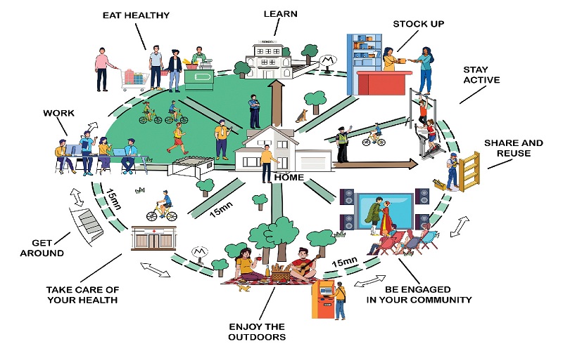
A neighborhood scoring system assesses the quality of a specific location through automation and uses various algorithms and geospatial data to achieve this. It handles multiple tasks, such as data collection on aspects like safety, amenities, crime, infrastructure, population, air quality, cost of living, noise levels etc. It collects data on the geographical features of a neighborhood, such as land use and boundaries.
The data may also include information on infrastructure such as school details, parks, and hospitals. It may also include data crime rates and noise levels in the location., and other vital information such as housing prices, rental rates, availability of public transport and access to amenities in the neighborhood.
How does a neighborhood scoring system work?
A neighborhood scoring system is a handy tool in city design and planning. It assesses various characteristics of a certain geographical area, helping stakeholders make decisions. It helps citizens determine where to invest, develop or live based on the available data. The information is useful for real estate investors, planners and governments since the data generated can be used to evaluate a neighborhood based on different metrics.
The tool uses a scoring algorithm and numerical data to calculate scores, and incorporates evaluations such as reviews and opinions. It then combines different criteria into a single score for a neighborhood. Common criteria include safety, amenities, transport, healthcare, demographics, economic factors, etc.
Why a neighborhood scoring system is vital in city design and planning
A neighborhood scoring system plays a major role in city design. It evaluates the sustainability, livability, and functionality of a certain neighborhood, helping planners make better and more informed decisions. The tool uses various metrics and offers numerous benefits, making it a crucial tool in city design. Here are the advantages of adopting the system;
Improved quality of life
A neighborhood scoring system acess various aspects of a neighborhood, which aids in desicon making. Residents and key planners can use the data to make informed decisions on their livelihood, investments and development, which leads to enhancements in the area.
Resource allocation
The data collected by the neighborhood scoring systems helps in the allocation of resources in the neighrohood. And this helps identify areas that need improvement and investment opportunities. It also ensures efficient spending since public spending allocates resources to the rightful areas.
Environmental sustainability
The data collected includes green metrics and indicators such as green space, air quality and energy efficiency. It encourages sustainable practices to promote a safer environment for all residents.
Community engagement&Inclusivity
Data collected offers a clear picture of various aspects of the neighborhood and is easily accessible. It also involves opinions and inputs from the community members, ensuring inclusivity and transparency.
Conclusion
Adopting a neighbourhood scoring system in a community ensures better management of resources. It furnishes residents and planners with key information useful in various ways and is a powerful tool that ensures a safer and more sustainable environment.